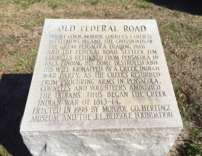
The Old Horse Path developed into the "Federal Road". The Federal Road is attributed to the growth and development of Monroe and Conecuh counties.
The Federal Road passed directly through the heart of Burnt Corn; it is Main Street for Burnt Corn. In 1805, the United States Congress established
a post road from Georgia to New Orleans. In 1818, the Post Roads Act was in full effect establishing Post Roads from Fort Mitchell, by Fort Bainbridge,
Fort Jackson, Burnt Corn Springs, Fort Claiborne, and the Town of Jackson to St Stephens. The post riders followed the Chiaha Alibamo and Old Wolf Path
trails and passed through Burnt Corn Creek. As the road improved and more white settlers were looking for land and encroached in Creek Territories helped
contributed to the Creek Indian Wars. Burnt Corn play an important part in the Creek Wars. It is said that the "Battle of Burnt Corn" was the beginning of
the Creek Wars. This battle was considered a victory for the Creek Indians, which was also known as "Red Sticks."
Back in 1806
when the Nation was still young and rapidly growing westward, a horse path
for postal riders was opened through the Creek Nation stretching from middle
Georgia to coastal Alabama. As the likelihood of another battle with Britain
increased, the crucial need to quickly move troops to protect the American
Gulf Coast was becoming more evident. In June 1810, Fort Stoddert's commanding
officer Col. Richard Sparks was ordered by Secretary of War William Eustis
to inspect and document these horse paths in order to mark a military road
so that troops and supplies could be sent to defend the Gulf Coast. A second
scouting party from Fort Stoddert was led by 1st Lt. John Roger Nelson
Luckett. Luckett made the first significant survey for road construction
in land that would later become Alabama. In addition to being charged to
keep journal notes of each day of his trip, Lucketts party carved Roman
numerals into trees marking each mile along their journey. On July 11,
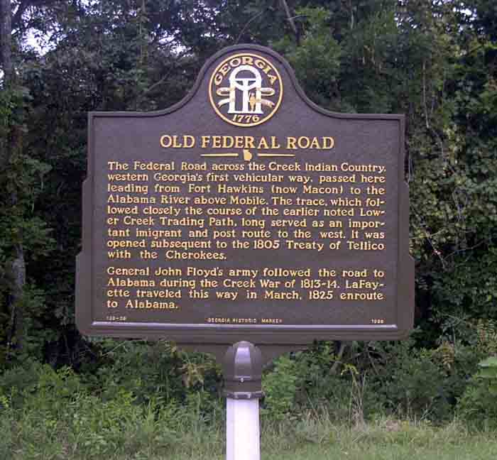
1811, Brigadier General Wade Hampton was directed to immediately begin
construction of three wagon roads through the Creek Nation the second
of these roads became known as the Federal Road.1
With construction at last beginning in 1811, the
Old Federal Road, was built from west to east connecting Fort Stoddert,
Alabama, to Fort Wilkinson, Georgia. (Several spelling variations include
Stoddert, Stoddart, etc.). Constructed in 1799, Fort Stoddert was named
for the Acting Secretary of War Benjamin Stoddert. Fort Stoddert was located
at the Mount Vernon Landing on the Mobile River in Mobile County east of
current day Mount Vernon. Located at the Federal Road's other end, Fort
Wilkinson was near Milledgeville
on the Oconee River in Baldwin County, Georgia. At that time, Milledgeville
was the capital of Georgia.
The Old Federal Road successfully connected Fort
Stoddert to the Chattahoochee River. At that point, the Federal Road merged
with the earlier postal riders horse path that linked Athens, Georgia,
to New Orleans, Louisiana. Unlike the old horse path, the Federal Road
went eastward making a connection with lands ripe for the recruitment of
soldiers and obtaining supplies for the military. This path quickly became
a major travel route for pioneers to the area once known as the Old Southwest.
From its start as a narrow horse path used to carry
the mails, the Old Federal Road underwent great development and became
a major military road connecting early American forts in the Creek Lands
and the Mississippi Territory. Acting as the interstate highway of its
day, when Alabama Fever raged through the Carolinas and Georgia, the
Old Federal Road carried thousands of pioneers to the Old Southwest. As
such, the Federal Road directly contributed to the dramatic increase in
Alabamas population between 1810 and 1820 with Alabamas population
growing far faster than that of either Mississippi or Louisiana during
this time. Alabama continued out-distancing both Mississippi and Louisiana
in population growth through 1850.2
The Federal Road became a well traveled stagecoach
route for those going through Alabama. In 1824, Adam Hodgson wrote Letters
from North America Written During a Tour in the United States and Canada
wherein he described his 1820 travel along the Federal Road from Chattahoochee
to Mobile. Hodgson found adequate over-night lodgings and described one
stop as having three beds in a log building with a clay floor. Noting the
ground formed a perpetual undulation, Hodgson concluded that [t]he road,
which is called the Federal Road, though tolerable for horses, would with
us be considered impossible for wheels.3
Nearly two centuries later, the Federal Road remains
visible. For those interested in making a modern day trip along this important
historical path, the Monroe
County Heritage Museums has marked the portion of the Federal Road
through Monroe County with eight monuments along its route from Prices
Hotel near the Monroe and Butler County lines through MacDavids Hotel
where the Federal Road continues through Escambia County, Alabama.
1The Federal
Road through Georgia, the Creek Nation, and Alabama, 1806 1836, p.
33-35.
2Id.
at p. 117.
3The Very
Worst Road, p. 8.
1814 Map of the
Mississippi territory showing Ft.
Stoddert
1815 Map of the
Country Belonging to the Cherokee and Creek Indians. Portions
of the Old Federal Road from New Orleans to Cowetta and Milledgeville
through the Lower Creek Nation is visible at the bottom of this map.
1813 Map of the
Southern Section of the United States including the Floridas and Bahama
Islands showing the Seat of War in that Department. Ft.
Stoddert, Alabama, (north of Mobile) and Ft. Wilkinson (south of Milledgeville)
are visible.
Please contact me about corrections, broken links, and additions.dabf@home.com
